Analysis of Data, Causal Factors, and Mitigation Lessons from the Sumatra Floods
Executive Summary
The last week of November 2025 was a dark moment for the Sumatra region. Wet hydrometeorological disasters—flash floods and landslides—struck simultaneously across three major provinces: Aceh, North Sumatra, and West Sumatra. As an entity that upholds the values of sustainability and safety, PAMITRA deems it necessary to examine this phenomenon not only as a tragedy but as a crucial case study on ecological balance and spatial planning. Based on data collected as of November 29, 2025, here is a comprehensive analysis of the anatomy of the disaster.
In late November 2025, Sumatra Island experienced one of the most destructive hydrometeorological disaster episodes in contemporary Indonesian history. This disaster, manifesting as flash floods, landslides, and debris flows (galodo), hit three key provinces: North Sumatra, West Sumatra, and Aceh. This report presents a comprehensive analysis of the catastrophe, integrating the latest data as of November 30, 2025, from the National Disaster Management Agency (BNPB), Antara News Agency, and analysis by environmental and meteorological experts. The situation on the ground shows a significant escalation of the humanitarian crisis with a total of 316 confirmed fatalities and 289 others still declared missing.
This phenomenon not only reflects Indonesia's geographical vulnerability but also highlights the complex interaction between global climate anomalies—marked by the rare presence of dual tropical cyclones near the equator—and anthropogenic environmental degradation that has been ongoing for decades. This analysis aims to dissect the meteorological dimensions, humanitarian impact, emergency response, economic losses, and the long-term health and environmental implications of this disaster, providing a foundation for evaluating national disaster mitigation policies.
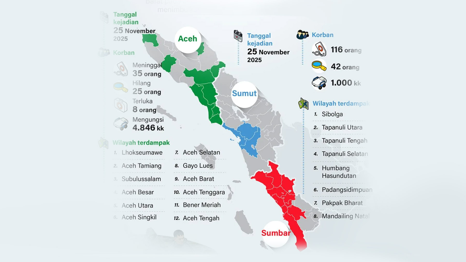
1. Scale of Impact: More Than Just Numbers
The disaster recorded a massive and widespread impact, underscoring the urgency of disaster management in Indonesia. Field data records:
2. Weather Anomalies and Triggering Factors
Why was the intensity of this disaster so extreme? Data analysis indicates a convergence of rarely occurring natural phenomena:
3. Environmental Factors: When Ecosystems Lose Carrying Capacity
The extreme rainfall met with degraded environmental conditions, creating an ecological disaster domino effect:
4. Regional Spatial Planning Challenges
In addition to natural factors, spatial planning analysis indicates systemic vulnerabilities:
5. Mapping of Critical Points
6. Solution Recommendations: Towards Disaster Resilience
From the analysis above, a holistic approach is needed to mitigate similar risks in the future:
The floods and landslides that struck Sumatra in November 2025 are a stark warning of the increasingly evident reality of the climate crisis. With 316 casualties, hundreds missing, and trillions of rupiah in material losses, this event underscores the vulnerability of our infrastructure and social systems to extreme weather anomalies. The deadly combination of rare meteorological phenomena (Cyclones Senyar and Koto at the equator) and environmental degradation due to human activity (deforestation and mining) has created a perfect storm that devastated three provinces simultaneously.
The government's response through the deployment of military forces and aerial logistics is commendable in preventing further loss of life, but the greatest challenge awaits in the recovery phase. For PAMITRA, this phenomenon confirms that economic development and infrastructure cannot be separated from environmental carrying capacity. Deep understanding of disaster risk and commitment to environmental governance (ESG) are key to a more resilient future for Indonesia.
Moving forward, reconstruction must not merely rebuild what was destroyed (business as usual). A radical evaluation of spatial planning along the Bukit Barisan mountain range, a firm moratorium on forest logging, and infrastructure adaptation resilient to extreme climate scenarios are required. Without these fundamental steps, Sumatra will continue to be under the shadow of increasingly intense hydrometeorological disasters in the future.
Data Source: Processed from BNPB reports and meteorological analysis as of November 29, 2025.
Photo/ Graphic: Antara News